Integrated assessment of land use and landcover changes and hydrological dynamics within the montane forest of Kenya

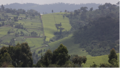
This project aims to build on our results of the land use mapping undertaken to investigate landuse changes over the past 100 years within the Kenya’s montane regions. Our focus is to evaluate how these land use and land cover (LULC) changes have altered hydrological processes in Kenya’s key montane forest catchments, including Mt. Kenya, Mau, Aberdare, Mt. Elgon, and Cherangany. By analysing historical river gauge data and applying hydrological modelling, the project seeks to quantify the effects of deforestation, agricultural expansion, and urban growth on river flow dynamics. These findings will be essential for understanding the cascading impacts of upstream environmental changes on downstream ecosystems such as the savannah lowlands and coastal mangroves, and for informing sustainable water resource management in the face of growing anthropogenic pressure.
This project will complement the long-term palaeoecological and historical ecology research project which focuses on sediment core analysis to reconstruct past ecosystem and climate dynamics in Kenya’s montane environments. Together, the two projects form a holistic approach to assessing environmental change—linking historical ecosystem trends with present-day hydrological responses to guide future conservation and planning efforts in Kenya’s rapidly changing montane and urban landscapes.


